

A Chinese company’s publication of AI-enhanced satellite images of US bases in the Middle East is helping Iranian forces identify targets, US intelligence believes.
The ABC has been briefed on the intelligence by a source inside US defence, who says the images are endangering lives.
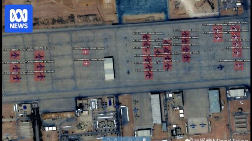
Chinese geospatial artificial intelligence and software company MizarVision, which the Chinese government has a small ownership stake in, has been publishing detailed satellite images with tagging data of multiple US military sites in the lead-up to, and during, the Iran war.
The imagery showcases an AI tool that identifies and tags military forces across vast areas, a capability that once required the resources of a national intelligence agency.
I think it’s that they realize peak oil is over. The middle east is a geopolitical strategic position for energy, as the world is now finding out via Iran closing the SoH.
Israel realised that that is on the wane. Along with the next generations attitude towards their relationshipnwith Israel. Israel is going hard in now as they have a larger support from the USA. I fully expect that to naturally wind down due to internal US political change and global moves away from carbon fuel.
Sure, oil shocks would still bite, but nowhere near to the same level. It’s why the other oil production states are desperately trying to pivot to other industries. Iran has screwed that by making them unsafe. America doesn’t realize that by not protecting their allies there, in the same way they protect Israel, that they will lose them. Edit:typos